Sunday 4 January 2015

Modern Geography
The study of geography went gone through many stages in the 19th and 20th century. The four main ones were environmental determinism, regional geography, the quantitative revolution, and critical geography.

Environmental Determinism                                       Environmental Determinism is the theory that the type of person you are is directly influenced by the environment you live in. It is the belief that a person’s natural environment affects their physical, mental and moral traits. The most common ideas are "heat makes inhabitants of the tropics lazy" and "frequent changes in barometric pressure make inhabitants of temperate latitudes more intellectually agile." Despite trying to keep the study scientific many geographers have dubbed it as sweeping generalizations with very little basis.

Regional Geography                                                             Regional geography is the belief that pure geography is the study of areas, regions and places. It includes information and description about the places and the right way of having earth divided into regions. Some geographers believe that it is too descriptive and not enough scientific evidence behind it.

Dividing Regions of the World

The Quantitative Revolution                                                        The Quantitative Revolution was a revolution that began in the 1950’s. This was a period when many geographers took geographical theories and scrutinized them in test usually using statistical methods.


Critical Geography                                                                   Critical Geography is similar in some ways to Environmental Determinism as it states how groups of people can be affected by the landscape they live in. It studies how a person can feel a sense of relationship with a region or area and how the natural environment can affect the social and political regimes.


Although the study of geography has changed and developed throughout the ages and different cultures, we will always enjoy learning and discovering new and exciting things about the wonderful world that we live in. There will always be the great questions that geographers can battle with like ‘How can a levee be dry?’ and ‘What makes one pine for the fjords?’.

American Pie by Don McLean            Monty Python – dead parrot sketch

Geography Expands
The interest in geography around Europe had grown in the 1400’s. A influential person in the popularising of geography was Ptolemy who created an ordered way of connecting and displaying geographical information and topics. Another cause of the growth in interest of geography was the age of exploration was an incredibly important time for geography. A geographer or cartographer was always preset on the successful expeditions to Africa and India. With the discovery of America in 1492 a whole new continent was open to geographers and the Pacific Ocean beyond.


The age of exploration revived a need for more geographical detail based on more solid theories. Gerardus Mercator’s world map and the writings of Bernhardus Varenius are both excellent examples of this more accurate form of geography. Waldseemuller, a German cartographer, also created maps of the world called Globe Gores which was one of the first that could be glued into sphere.


A Globe Gore
Middle Ages Geography
After the collapse of the Roman Empire many works of geography were to be found and the study of geography continued especially in Byzantine which was in Constantinople. There was much political divide there and Constantine VII wrote about the geography of the division in Byzantine which is the primary source today of political geography of the time.

Byzantine

The Syrian Bishop, Jacob of Edessa used the writings of Ptolemy, Aristotle, Theophrastus and Basil, who were Greek geographers, to created a detailed and structured diagram of the cosmos. Along with his picture of the cosmos he also wrote many texts in which he writes much more scientifically than his Greek sources and less theologically.

The Cosmos


While Jacob of Edessa studied texts and observed, Cosmas Indicopleustes, who was a merchant, did much travelling and went to places including India and today’s Ethiopia. Amongst the his writings of the places he had travelled to, Cosmas Indicopleustes also included Christian Topography were he crated many world maps. Although most Christian topographers at this time believed the earth to be round, Cosmas Indicopleustes believed it to be flat. However, geographers knew that the earth was spherical much earlier in BC times through many different experiments. One was measuring the length of the shadow of a stick in the ground from two different places on the earth and then working out the curvature of the earth.  

Flat Earth


The Beginning of Geography
The time I have chosen to start my blog is 600 BC in ancient Babylon as this is the earliest record of a world map. This map is called the ‘Imago Mundi’ and depicts Babylon in the centre of the world. Several texts accompanied the map describing the world as they saw it and five of the texts have survived along with the map. However, the word ‘geography’ was used much earlier then the Imago Mundi and was first written in 270 BC by Eratosthenes, who is said to have founded the area of science we now know as geography and is famous for calculating the circumference of the earth. 

                                        Eratosthenes                                Imago Mundi 


At a similar time, the ancient Greeks believed Homer, the poet and not the beloved television character, to be the founder of geography.  Many of his works of literature including the Odyssey contain large amounts geographical knowledge mainly referring to the Mediterranean.

             
             Homer the poet                        Homer the beloved television character

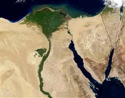
Hecataeus of Miletus, who was also a Greek, was one of the first to apply a practical element to geography. He gathered both previously written texts and physical specimens for his studies. He also often spoke to sailors who came to the busy ports to get accounts of the wider world. Through these accounts and his own studies, Hecataeus wrote detailed descriptions of the known world. He was also the first to discover and write about river features such as deltas and that winds blow to warmer regions from colder ones.


The Nile Delta

Although Eratosthenes is famous for finding the circumference of the earth, it was Pythagoras who first proposed a spherical earth. He deduced this because he noticed that a curved shadow is created by the earth during an eclipse and that the further north you move, the higher the stars become. From this discovery of a spherical earth,  Eudoxus of Cnidus explained how different climate zones are crated by the sun based on latitude.


Climate Zones


What is the Geography of Geography?
I am writing about the geography of geography. In the beginning I found this title quite challenging and I struggled to grasp it. To over come this and get my head round it, I looked up the definition of geography and found it was:

A field of science dedicated to the study of the lands, the features, the inhabitants, and the phenomena of the Earth. A literal translation would be "to describe or write about the Earth".


Therefore I will be writing about, in terms of the lands, the features, the inhabitants, and the phenomena of the Earth, the describing of the earth or more simply I will be writing about how people described the earth. I want to learn how the study of geography has changed of differs between different cultures, ages, regions and political groups.
Introduction

Hello, my name in Sam and I am a transition year student. In this blog I will be writing about the geography of geography. I chose to write about the geography of geography as I wanted to write about a topic which was out side of the box and slightly different and interesting.